|
Materials:
1. Overhead projector
2. Overhead transparency which can be fed through a copy machine
3. Copy of a map used for area of study (plain map with only borders)
Here are some maps you can use:
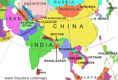
Map 1
Map 2
4. Poster board or white sheet
5. Markers, crayons, colored pencils, etc
6. Tape
7. Geography textbook, atlas or any other reference guides
Procedures:
1. Divide class into groups of 3-4. Provide a transparent
map, markers, and any other writing utensil.
2. Using the overhead projector, focus the transparency onto a poster
board or sheet that you have tapped to the wall. Make sure the students
are aware that the image may move if the overhead is touched. (Repositioning
the image is difficult and may create an inaccurate outline)
3. When the image is complete, have the students shut the overhead
off and take their map off the wall.
4. Using reference guides, assign students seperate tasks in order
to complete their map. Tasks should include key features that will
be studied in class. Assigning seperate tasks will give each student
the opportunity to take part in the project.
5. Have each group present their map and explain what they drew.
- Features to consider on the big map include:
1. Geographic Features: major rivers, mountains, elevation, deserts,
etc
2. Cultural Factors: religions, languages, ethnicities, etc
3. Political Features: borders, countries, major cities, regions,
etc
Other aspects to consider:
Have students obtain pictures from magazines and internet sites
of people, animals, artwork, plants, and key features. Place these
images in the appropriate spots on the map to which each picture
is describing.
Resources:
Lesson: Asia
Map Puzzle
- Interactive maps piecing countries together
Resource: Asia
Directory
- Photos and interactive maps
Resource: Free
Maps
- List of accessible maps of Asia
Resource: National
geographic resource for online maps
|
 Making
maps is a great way for students to introduce themselves to a
particular country, region, and/or natural features. Depending
on what you would like to teach a particular class you may have
them copy political,
Making
maps is a great way for students to introduce themselves to a
particular country, region, and/or natural features. Depending
on what you would like to teach a particular class you may have
them copy political,