|
City of Bristol,
Historic Maps and Market Cross
 Margery
Kempe visited at a time when Bristol was at the height of its economic
and cultural power. Bombing during World War II has destroyed much of
the medieval heritage of the city, where parish churches, religious foundations Margery
Kempe visited at a time when Bristol was at the height of its economic
and cultural power. Bombing during World War II has destroyed much of
the medieval heritage of the city, where parish churches, religious foundations
 of
orders such as the Franciscans, and charitable foundations where once
on virtually every significant street. The city owed its importance to
its deep river that predictably rose and fell with the incoming tides.
Once within the river's protection, the ships found a safe harbor. Almost
all trade with Ireland and Spain was directed through Bristol. Margery
Kempe's voyage to the shrine of St. James of Compostela on Spain's northern
coast was most efficiently accomplished by sailing from Bristol. William
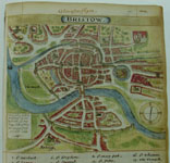
Smith's map of Bristol dates 1568 shows the importance of the river system
to the city. of
orders such as the Franciscans, and charitable foundations where once
on virtually every significant street. The city owed its importance to
its deep river that predictably rose and fell with the incoming tides.
Once within the river's protection, the ships found a safe harbor. Almost
all trade with Ireland and Spain was directed through Bristol. Margery
Kempe's voyage to the shrine of St. James of Compostela on Spain's northern
coast was most efficiently accomplished by sailing from Bristol. William
Smith's map of Bristol dates 1568 shows the importance of the river system
to the city.
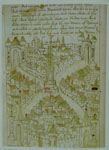
  Robert
Richart's plan of Bristol, drawn in 1480, gives a good indication of the
city that Kempe visited, with its two great avenues intersecting at the
market crossing. The avenues terminated in four city gates, similar to
those extant for York. The city boasted a great market cross erected in
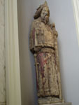
1400. Typical of many crosses, if perhaps more lavish, the market cross
was decorated with life-size statues of kings of England carved in stone
and painted in polychrome. Four have survived. The market cross was finally
dismantled in 1762, and bought by Henry Hoare for his estate of Stourhead,
Wiltshire. In 1890 copies were put on the cross and the originals, owned
by the National Trust, are on loan to the Victoria and Albert Museum,
London. Robert
Richart's plan of Bristol, drawn in 1480, gives a good indication of the
city that Kempe visited, with its two great avenues intersecting at the
market crossing. The avenues terminated in four city gates, similar to
those extant for York. The city boasted a great market cross erected in
1400. Typical of many crosses, if perhaps more lavish, the market cross
was decorated with life-size statues of kings of England carved in stone
and painted in polychrome. Four have survived. The market cross was finally
dismantled in 1762, and bought by Henry Hoare for his estate of Stourhead,
Wiltshire. In 1890 copies were put on the cross and the originals, owned
by the National Trust, are on loan to the Victoria and Albert Museum,
London.
See: "Almost
the richest city": Bristol in the Middle Ages / edited by Laurence
Keen, London: British Archaeological Association, 1997.
|

