
|
Physical Systems For teaching the physical systems of the Himalayan region, students should understand:
To get students to understand the physical geography of the region, I plan to adapt a lesson plan called Big Maps. I will create a weeklong mapping activity that I will use everyday as a warm-up. Here is my plan: Day 1: Students will create the outline map with boundaries. Day 2: Students will create a political map by labeling countries and cities. Day 3: Students will create a physical map by labeling important physical features. Day 4: Students will create a cultural map by labeling important language or ethnic regions. Day 5: Assess with map quiz This lesson plan can be adapted to focus on important areas of study.
From the article, "The Collision between India and Eurasia," by Molnar and Tapponier in the Scientific American, I got the idea to use a comparative analysis of the Himalayas with the Rocky Mountains. On an overhead, I will superimpose the U.S. map on a Himalayan region map. See the idea here. Here are some places where you can find some map resources: National Geographic Map Machine
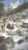
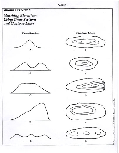
The Himalayas are a wonderful place to introduce or integrate the five themes of geography. I plan to use it as a two week unit after I have introduced the five themes and map skills to reinforce the idea of region. Here you will find some five themes notes as they apply to the Himalayan region. Since my students have the Rocky Mountains as a reference point, I plan to compare the Rocky Mountain region to the Himalayan region. I will adapt a National Geographic lesson with new information taken from Mimi Stephens at Clark University. Even though the lesson is K-2, I will adapt it to middle schoolers by integrating it into a topographic map unit. Here are the following resources that I will use as I develop the lesson plan: Life in the Mountains National Geographic Lesson Plan Contour Maps-Dogtails Lesson Plan Matching Elevations Using Cross Sections and Contour Lines What is a Mountain Graphic Organizer What Do Mountains Mean to People? Additional links that I have found particularly useful are: a 2000 satellite image view of the Himalayan region NASA satellite photos of the Himalayan region and the Tibetan Plateau How the Himalaya formed; future of the Himalaya Origin of the Himalayas explained The Himalayas: Two continents collide
Geological processes: A Region for Earthquakes
Earthquake facts, photos, slideshow, maps History, plate tectonics, prediction of earthquakes, activities, graphics, photos, links Seismology: past and present, plate tectonics, earthquake safety Earthquake facts along with questions I plan to use pages 142-143 from the Discovery Channel's Atlas of the Prehistoric World by Douglas Palmer to discuss the Himalayas and the Tibetan Plateau. I also use an interactive slideshow from our McDougall Littell science series that has a decent slideshow on Topographical Maps and Earth Surface Features.
Students should understand that microclimate and monsoons affect the Himalaya region. Important vocabulary to introduce would include: topography, slope, elevation, relief, rain shadow, contour lines, and monsoon. Here are some climate links that I will use in the development of a climate project: General info on Himalayan climate Climatic conditions in the Himalaya Nepal’s climate and topography broken down by regions Himalayan climate ranges, elevation changes, and monsoon effects News article: Climate change ruining Mt. Everest
Other important physical systems in the Himalayan region are glaciers and rivers. I plan to create an interdisciplinary lesson with my team’s science teacher, incorporating additional lessons when he teaches glaciers and rivers in an erosion unit. These activities might include:
Altitudinal Zonation Students will work in groups to cut out magazine pictures or draw vegetation and animals that one would find in each zone. They will create a wall graphic of altitudinal distribution that may even be displayed as an ongoing unit, similar to the Big Maps. These diagrams will be helpful in creating altitude zones: General Altitudinal Distribution of Vegetation and Large Mammals in the Himalayas Altitudinal and Latitudinal Zonation
|
||||||||


 These links are good earthquake websites:
  Climate
This site was created by Amy Jane Priest at the NEH Summer Institute "Cultures and Religions of the Himalayan Region," held at the College of the Holy Cross, Summer 2006