OBJECTIVE
• To familiarize students with the political,
regional, and cultural boundaries of the Himalayan region.

epsc.wustl.edu/seismology/ fieldprojects.html
TIME
NEEDED FOR LESSON
• 3 1-hour class periods
PRIOR KNOWLEDGE
NEEDED
• Students should take part in the lesson
“What is A Mountain?”
prior to this exercise.
• Students should be familiar with the region as a whole.
A discussion of areas of dispute, such as Kashmir, would be helpful.
A preview of areas, such as Jammu, Assam, Dolpo and Mustang would
increase their interest. (See “Region Descriptions"
below)
MATERIALS
• Atlases throughout classroom. A highly recommended
source is a classroom set of The State of the World Atlas, sixth
edition (by Dan Smith) (Penguin Books Limited) (1999) (IBSN# 0-14-051446-5)
• 1 set of project directions per group – overall directions
plus individualized tasks (see Big
Map Project Directions)
• 1 overhead projector for every 4 students
• 1 large poster board or pre-cut sheet of paper per group
• 1 overhead map transparency per group (see Map
of The Himalayan Region)
• 1 set of photocopied maps (see Himalayas
- Map Packet) per group
• Pencils
• White out
• Black Sharpies
• Colored Pencils
• Clay for relief features
• Paper copies of overhead map for homework assignment
Maps provided by Himalaya: Life
on the Edge of the World (by David Zurick and P.P. Karan) (Johns
Hopkins University Press, 1999) (ISBN#0-8018-6168-3) and Teacher
Center for Global Studies at Clark University.
VOCABULARY
LIST
• Political boundaries- land boundaries that
are decided upon by a government, governments, or world organizations.
• Regional boundaries-boundaries that demonstrate a broad
geographical area distinguished by similar features (such as religion,
language, climate, fauna, physical traits, resources…).
• Relief map- topographic depictions of relative positions
and elevations.
• Submontane- at or near the foot of mountains.
• Midmontane- at or near the middle elevation of mountains

www.travel.co.ck/ map-india.htm
TEACHER INFORMATION
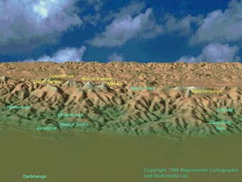
The definition
of the Himalaya from Webster's New Geographic Dictionary (1988):
"A mountain system bordering the Indian subcontinent on the
North is a 1500 mile long arc extending from Jammu and Kashmir
in the west to Assam in the east and covering most of Nepal, Sikkim,
Bhutan, and the southern edge of Tibet. Separated from the Karakorum
Range in the northwest by the Indus River and bounded on the north
and east by the Brahmaputra River. Divided into three main regions:
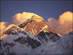
the greater Himalaya in the north, which includes Everest; the
lesser Himalaya in the center; and the outer Himalaya in the south,
including the Siwalik Range.
Elevations:
Nanda Devi – 7,816 m
Annapurna – 8,091 m
Everest – 8,848 m
Kanchenzonga – 8,598m
www.dlynnwaldron.com/
airmanid.html
Region Descriptions:
Kashmir- a historical region of northwest India and northeast
Pakistan. Conquered by the Mogul emperor Akbar in 1586, it later
came under the control of Afghanistan (1757) and a Sikh empire
(1819). After 1846, it was part of the princely state of Jammu
and Kashmir. Ownership is currently a source of violence and dispute
between India and Pakistan.
Jammu- a city of northern India near the Pakistani border
south of Srinagar. Formerly the seat of a Rajput dynasty, it was
later captured by the Sikhs.
Assam- a former kingdom of extreme northeast India, now
a state of India. It is separated from the rest of the country
by Bangladesh. The kingdom was founded by invaders from Burma
and China in the 13th century.
Dolpo- one of the highest inhabited areas of the Himalayas,
lying between the Tibetan Plateau and the Dhaulagiri Himal range.
It is referred to as the Bon Kingdom due to its strong ties to
the pre-Buddhist religion of Bonpo. The route travels through
forests and high valleys before reaching the mountain passes that
rise towards the snow peaks of the Kanjiroba Himal, the Kagmara
Lekh and the vast Tibetan plateau. This area overlooks the five
peaks of Dhaualgiri.
Mustang- the
ancient and mysterious Kingdom of Lo. Owing to an old treaty between
Nepal and China, Mustang was saved from being a part of the People's
Republic when their forces invaded Tibet in 1959.
Sikkim - a region and former kingdom of northeast India
in the eastern Himalayan Mountains between Nepal and Bhutan. Sikkim
was settled by Tibetans in the 16th century and became a British
protectorate in 1890. Sikkim passed to India in 1949 and became
a state of that country in 1975.
HOMEWORK
• On hard copies of the same projected blank
map, students should fill in political borders of countries, major
cities, major rivers, mountains and regions.
• Students should read textbook chapters and answer questions
on how the physical features affect the way of life in the Himalayas.
FURTHER RECOMMENDATIONS
Teachers may want to read Chapter 2 of the book,
Himalaya: Life on the Edge of the World (by David Zurick and P.P.
Karan) (Johns Hopkins University Press, 1999) (ISBN#0-8018-6168-3)
for background information on the mountain contours of this region.
To read a diary entry from a trekker who traveled
from Upper Dolpo to Mustang, go to TibetFocus.com
For great pictures of Mustang, go to Mustang
Valley