| The
Basics for Students
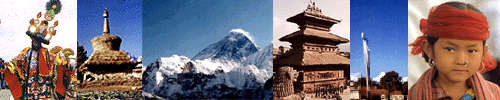
As you travel through the Himalayas
you will meet people with different kinds of clothing, carrying different
goods, displaying various religious symbols, and speaking many languages.
There are hundreds of ethnic groups, languages and settlements in the Himalayan
region, but people throughout the region have learned to exploit the waterways
and river valleys to meet their needs. Therefore, to understand where
you are in the Himalayas and who you are speaking with you
really need to know only two basic pieces of information:
which
river system you are
following and your relative
elevation.
There are three great river systems
that cut through the Himalayas: the Indus,
the Ganges and the Tsangpo/Brahmaputra. These rivers can each be
divided into three regions based on elevation. They all have their
headwaters on the Tibetan Plateau and cut through the high Himalayas, all
three pass rapidly through the mid-montane region and finally all of the
rivers flow more gently from the mountains onto the lower elevation plains.
People have developed unique strategies
to live along each of these waterways and within each elevation region.
In this unit you will have the opportunity, as a class, to explore the
three elevation regions along the three major river systems of the Himalayas.
As an individual, however, you will only be responsible for one portion
of this material, a single river system at a single elevation region.
To continue through
the unit click here.
|