| Home| | Geography| | Jatakas| | Literature| | Mandalas at Work| |
|
 |
 |
Nepal and Himalayan Region Information| Sacred Mountains Lesson| Geography Themes and Poetry|Tiger Tiger The geography of the Himalayan Region is expansive and diverse. Furthermore, the study of Nepal will provide an exciting "trek" into a land that ranges from the jungle to the mountains in an expanse of approximately 100 miles.
The following information taken from The Himalayas: A Syllabus of the Region's History, Anthropology, and Religion by Todd T. Lewis and Theodore Riccardi, Jr., 1995. 1. The prevailing geographic feature of the area is the Himalayan Mountain Range, a young mountain range (25 million years old) and it is still rising. Young mountains are characterized by their sharp peaks whereas older mountains like the Appalachians have rounded off peaks due to soil erosion. 2. The region is unique because of the tropical heat at one end and the arctic cold, all which can occur within 50-100 miles, thereby creating a rich variety of life. 3. Regional climate: in general, eastern areas wetter than western areas because of yearly monsoons. 4. Regular vertical zonation patterns: Mean temperature drops 11 degrees F for every 3,400 feet increase in altitude; Treeline coincides with elevation levels and higher on southern exposures than northern. Geographical and Climatic Characteristics: 1. The Submontane Region: Land below 2,500 feet, vast tropical forests cleared for settlement after eradication of malaria; very hot summer season and land inundated during monsoon season; Brahmaputra Valley a distinct sub-region.
2. The Mid-montane Region: Land from 2,500-7,500 ft. from Kashmir to Arunachal Pradesh; major rivers that have their headwaters on the north side of the high Himalayas and cut through the entire region; mixed hardwood forests along bamboo and rhododendrons; temperate climate; most areas inhabitable;large valleys that have support centers of civilization Kashmir Valley and Kathmandu Valley, Nepal.
3. Highlands Region; Lands above 7,500 ft on both sides of the Himalayan peaks; landforms have inhabitable areas across the mountain range, upland plateaus and valleys, shaped by major rivers, glaciation and avalanches; hardwood and evergreen forests give way to scrub species at 14,000 feet; cold climate with short growing season and severe winter conditions. Geography supplements
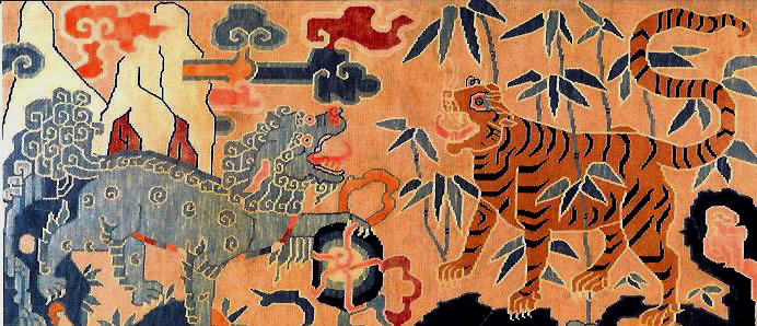
Students of geography will also be interested in the various mountains and the fact that Nepal, birthplace of the Buddha, hosts some of the tallest mountains in the world, for example, Mt. Everest, K2, etc. But it is the travel from Lumbini, at the far south central side of Nepal to the Annapurna Himal which will provide an encounter with diverse wildlife, plants and lifestyles of the Nepalese people. Lions, tigers, snow leopards, snakes, monkeys and elephants are often depicted in Newar Buddhist and Hindu art from the region. Newars are the people who live in Nepal. One may also read some of the epic literature about the birth of the Buddha on the Literature page of this website to gain a richer illustration in words of the valley in Lumbini. On this page are several links to Google Maps for certain locations in the area of Nepal and Tibet. Some of the mountains had to be accessed according to their latitude (the coordinates that are running North and South of the Equator, also running across or horizontal on the globe) and longitude (the coordinates that are running East and West from the Prime Meridian, or running up and down or vertical on the globe). Recommendation to download latest Google Earth program onto hard drive. This is a free download! A pdf short lesson about mountain building, the Himalayan Mountain range and the frequency of earthquakes in Nepal is included . Mountain Orogeny:Nepal's Earthquakes Also on this page are links to several mountains across the world that are considered sacred. Not every culture chooses to climb mountains and the mountain may hold a specific and significant honorary value for that culture.The first lesson is the Sacred Mountain lesson. |
|
|
The 5 Themes of Geography are a foundation for instruction of geography. One can cover many topics just by aligning to the 5 themes which are:
Writing and Geography can go together. Often the best information about a foreign culture and its landscape has been in travel journals. In this exercise, the student will write a Geopoem that reflects some of the many characteristics about the Himalayan Regions. The exercise is not necessarily a formula but there are some guidelines to help student writers get started. The introduction of the 5 Themes of Geography are helpful to get ideas across in the poem. Listed below is the GEOPOEM format: Line 1. City/country name Below is an example of a poem written about Lumbini, Nepal. Some freedom was taken with the format, but it is poetry, after all! |
|
|
 Young interest in kite flying in Kathmandu Valley, Nepal. |
 |
Tiger Tiger |
|
Tiger Tiger focuses on the tigers of the submontane region of Nepal, the lush southern area of the country where Lumbini is located. Tigers show up often in the literature about the Buddha, in the jatakas and often in the art from this area. The subject is timely and controversial since tigers are quickly losing their habitat to rapid human encroachment, poaching and land development. Tigers can be evaluated from the various websites that contribute much more factual information on their current situation.
Researching the tigers of Nepal will cross over into many other geographical areas of the world where tigers are threatened and endangered: India, Thailand, Sumatra, Russia, Korea,these are only a few. One could basically study the many problems that big cats are facing: a loss of habitat and life and compare how the region where they live is managing the problem. A healthy habitat for the tiger is also a healthy habitat for humans and there has to be a way for man and tiger to coexist. A special thanks to Prof. David Smith, University of Minnesota for your compassion and driven desire to save tigers in the wild of Nepal and other areas of South Asia.
|
Finally, the Himalayan Region is replete with intersecting ideas that express the 5 Themes of Geography. Furthermore, one may never get tired of reading and looking at pictures from the region; it truly is rich in history and diversity. Suggestions for further research:
|
| This site was created by Diana T. Mackiewicz at the NEH Summer Institute "Literatures, Religions, and Arts of the Himalayan Region," held at the College of the Holy Cross, Summer 2011. |