
Heidi Kaiter
Concord Middle School, Concord, MA
~The Himalayas~
|
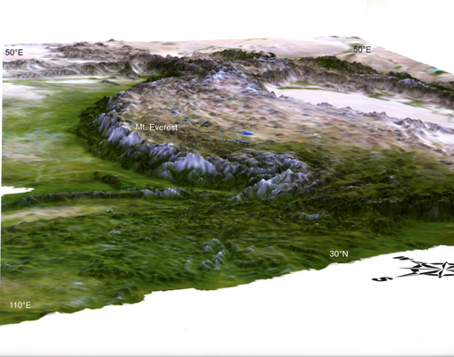
Introduction: The Himalayan mountain range is the highest and one of the youngest mountain ranges on Earth today.
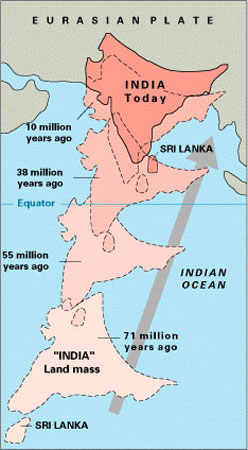
It formed due to the collision of two tectonic plates around 40 million years ago, and the convergent activity continues today, causing earthquakes in the region and continued uplift of the land.
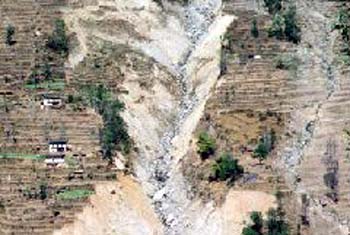
But, like all mountains, the Himalayas are also subject to the powers of erosion and deposition, affecting farmers as well as houses, roads and bridges.
Erosion happens. The Himalayas provide a windward barrier for the seasonal monsoon rains, which fall in the lush valleys of the low Himalayas and foothills.
The Tibetan Plateau watershed is the source of many major rivers, providing fresh water to literally millions of people in India as well as other countries.
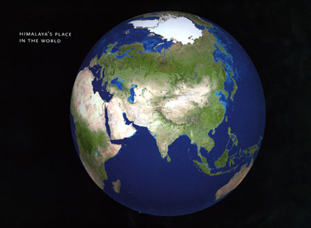
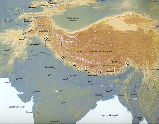
Today, the Himalayan zone represents the frontier boundary between two of the world's most populated countries: China and India. It is a region rich in cultural, political and religious history. The lifestyles of the people living in the Himalayan zone are in many ways shaped by the landscape itself.
(See the five curriculum ideas presented below.) ~ Click on the photo gallery link entitled: Formation of the Himalayas for maps and pictures that show the Himalayan mountain range, its formation and country boundaries. ~ Five curriculum ideas for teaching about the Himalayas 1) Big Map - Project a blank outline map of Himalayan country borders on a wall covered with a large piece of paper using an overhead projector. Trace the borders on the paper with bold felt-tipped markers. Using a detailed atlas of Asia as a guide, have students label the following on the big map: country names & regions & capitals, mountain ranges, rivers, longitude & latitude, oceans & seas.
2) Pangaea and Beyond - Draw a large oval on a bedsheet to represent the shape of Earth. With scissors, cut out the oval. Draw a center line on the sheet representing the equator. Spread the bedsheet on the floor of the classroom. Using multi-colored construction paper, cut out and label shapes of continents of a scale that matches bedsheet Earth. Assign groups to place the landmass cutouts on the floor as they were located 250 million years ago. Each successive group will move the pieces to their positions in 50 million year increments, paying particular attention to track the location of India. Use this activity to describe how the Tethys Sea disappeared and Himalayan range formed. Predict how the Himalayas may change 50 million years into the future.
3) Play www.tibetgame.com - Wander through virtual Tibet. Earn karma points to reach nirvana!
4) Zones of Change - Identify the following zones on a map of Asia: Ganges Plains, Terai Forest, Mid-Montaine Valley, Himalayan Highlands, Plateau. Match the following lifestyle that would best apply to each zone: terraced rice farmer (Bhutan), nomadic yak herder (Tibet), tiger reserve national park ranger (Nepal), sherpa trekking guide (Nepal), ferry boat tour guide (India). Research one country and lifestyle of choice by doing a web quest. Write a journal entry that describes a day in the life of your named character.
5) Suitcase Show and Tell - Assign student groups a country or region in the Himalayas of Asia: Pakistan, Afghanistan, Nepal, India, Bhutan, Tibet, China, Bangladesh, Myanmar or Sikkim. Students in each group will research their country, then bring in actual items or pictures that are representative of the following topics to be placed in their suitcase or sack: culture, religion, traditional attire, holiday traditions, architecture, flag, map, regional cuisine, famous people (artists, leaders etc.), agriculture, local flora, local fauna, music, etc. Students will teach the class about their country by selecting, displaying and explaining items from their travel bag to the class. This unit could culminate with a regional feast and class cookbook. __________________________________________________ Himalayan Fun Facts:
FYI: In 1955, the elevation of Mount Everest was measured to be 29,028 feet above sea level (8,848 meters). This figure was revised on November 11, 1999, and Everest now stands at 29,035 feet above sea level (8,850 meters). ....................................................
FYI: The top 14 mountains of the world with the highest elevation are all in the Himalayas. See chart below: (Mountain name - Location - Height meters - Height ft. - First to summit - Nationality - Date first climbed) .............................................................................................. 1. Everest - Nepal/Tibet - 8,850 - 29,035 - Tenzing Norgay/Nepal & Edmund Hillary/New Zealand/UK - May, 29, 1953. 2. K2 - Pakistan/China - 8,586 - 28,250 -A. Compagnoni & L. Lacedelli - Italy - July 31, 1954. 3. Kangchenjunga - Nepal/India - 8,586 - 28,169 - G. Band, J. Brown, N. Hardie, S. Streather - UK - May 25, 1955. 4. Lhotse - Nepal/Tibet - 8,516 - 27,940 - F. Luchsinger, E. Reiss - Switzerland - May 18, 1956. 5. Makalu - Nepal/Tibet- 8,463 - 27,766 - J. Couzy, L. Terray, J. Franco, G. Magnone, Gialtsen, J. Bouier, S. Coupe, P. Leroux, A. Vialatte - France - May 15, 1955. 6. Cho Oyu - Nepal/Tibet - 8,201 - 26,906 - H. Tichy, S. Jochler/Austria & Pasang Dawa Lama/Nepal - October 19, 1954. 7. Dhaulagiri - Nepal - 8,167 - 26,795 - A. Schelbert, E. Forrer, K. Diemberger, P. Diener/Switzerland & Nyima Dorji, Nawang Dorji/Nepal - May 13, 1960. 8. Manaslu - Nepal - 8,163 - 26,781 - T. Imamishi, K. Kato, M. Higeta/Japan & G. Norbu/Nepal - May 9, 1956. 9. Nanga Parbat - Pakistan - 8,125 - 26,660 - Hermann Buhl - Austria - July 3, 1953. 10. Annapurna - Nepal - 8,091 - 26,545 - M. Herzog, L. Lachenal - France - June 3, 1950. 11. Gasherbrum I (K5: Hidden Peak) - Pakistan/China - 8,068 - 26,470 - Pete K. Schoeing, Andy J. Kaufman - USA - July 4, 1958. 12. Broad Peak - Pakistan/China - 8,047 - 26,400 - M. Schmuck, F. Wintersteller, K. Diemberger, H. Buhl - Austria - June 9, 1957. 13. Gasherbrum II (K4) - Pakistan/China - 8,035 - 26,360 - Fritz Moravec, Joseph S. Larch, Hans Willenpart - Austria - July 7, 1956. 14. Shishapangma - Tibet - 8,013 - 26,289 - Hsu Ching & team of 9 - China - May 2, 1964.
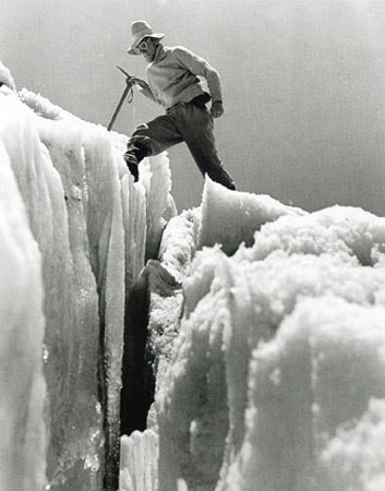
Crevasse, Everest ................................................................................................ FYI: The original name for Mount Everest is Chomolungma, the goddess mother of the world, according to local lore.
Sir George Everest
Related Links: college.holycross.edu/projects/natural_hazards college.holycross.edu/projects/physical_systems
|
%20of%20Map_Monsoon.jpg)
%20of%20Map_HimaRivers.jpg)
%20of%20George_Everest.jpg)
This site was created by Heidi Kaiter at the NEH Summer Institute "Cultures and Religions of the Himalayan Region," held at the College of the Holy Cross, Summer 2006.