[Assawompset School, Lakeville, Massachusetts]
Himalaya Thematic Unit for Second Grade]
| HOME |
| Introduction |
| Where are the Himalaya? |
| Regions within the Himalaya |
| Poetry and other activities |
| Resources |
Where are the Himalaya Mountains?
Modern geographers restrict the term Himalaya to the mountain region between India and Tibet enclosed within the Indus and Brahmaputra (Yarlang-Tsangpo Rivers). They stretch for 2,700 km. and pass through Nepal, India, including Kashmir and Sikkim, Tibet, Bhutan, and Pakistan. It is the world’s highest mountain chain.
Activity 1: Children will find the Himalaya in South and Central Asia region on the classroom globe and maps. Given a map of Southern Asia, they will use a map key and color the Himalaya. They will find the Indus and Brahmaputra Rivers.
Activity 2: Some classes might be given a big map of the area with the Indus and Brahmaputra Rivers drawn in, whereby students can then include the Himalaya, Everest, and other major points on the map, using a map key.
Activity 3: After a brief explanation of plate tectonics and the collision of India into Asia, students can see how mountains are made, using the computer center.
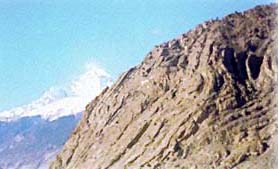
This picture shows the folding of rocks when plates collide.
Activity 4: Use 2 different colored layers of clay to represent those of the earth's crust and upper mantle. These 2 layers will represent the lithosphere, the 93 mile thick plates which shift from hot zones to cooler zones, forming the continental drift. Place the layers on top of one another. Slide the outer edges of the clay toward the middle to form a folded mountain.